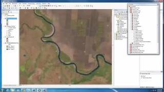
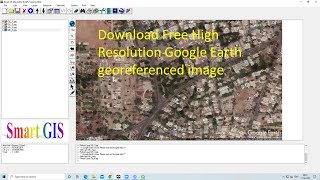
QGIS Lessons-3 Interface of Google Earth Pro u0026 QGIS
In this Lecture we will learn how to Download Google Earth Pro then we will going to see Interesting facts about the google earth Pro then we will learn how to Digitize Point, Line & Polygon in Google earth,Calculate length & Area,Elevation profile,Georeference google earth image in to Qgis finally we will see How to generate contours and DEM from google earth Pro.
Geotech GIS Training institute is a prestigious remote sensing training institute in India. Our vision is to bring an opportunity to every aspirant who dreams of a successful career in remote sensing and GIS field.
We conduct the following courses:
Training Program Related to Project Work Duration 1 Month
Basics of Remote Sensing and GIS Duration 3 Months
Advance Diploma in Remote Sensing and GIS Duration 6 Months
PG Diploma in Remote Sensing and GIS Duration 1 Year
Master of Remote Sensing and GIS Duration: 2 Years
Join our telegram Group
Remote Sensing & GIS Professionals :
https://t.me/joinchat/UhUorR2yhloKeKP...
Special Thanks for What I am Using
Software: https://amzn.to/3BO5IMF
GIS BOOKS: https://amzn.to/3xmM333
Mic: https://amzn.to/3iYN77P
HP Desktop: https://amzn.to/3iYqSPz
lesson1: • QGIS Lesson1 QGIS absolute beginners...
lesson2 : • QGIS Lesson2 Digitization in QGIS, D...
Any Help Contact
Mr.Vikas [email protected]
WhatsApp Number= +918421031398
Mr.Aniket Borgawkar+919096244262, +919284471310
Email Id: [email protected]
Shivali Deshmukh Email Id:[email protected]


![Power BI Dataflows Tutorial and Best Practices [Full Course]](https://i.ytimg.com/vi/GuU6_cqu8FE/mqdefault.jpg)