HIMALAYAS - The Geographic Documentary

#himalayas #trekking #hiking #mountaineering #nature #naturephotography #travel #tour #geography #himalayangeography #howhimalayaborn #himalayan #himalayannews #climatechange #history
From 240 Million years at the time of Beginning to till the Day in 6 Minutes
Presented By: THE CLIMBERS, Kolkata
Edit, Script and Voice Over: MountainSubhajit
The History of forming the Himalayas:
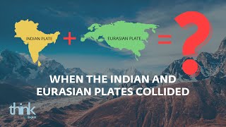
Himalayas, the land of the God! It divides the Tibetan plateau, from the great Indian subcontinent.It all started 225 million years ago, in geologic time. The Pangea, which means “all lands”. That was a supercontinent formed a single landmass on Earth. Here, India was a large island, and situated off the Australian coast, separated from Asia by the Tethys Ocean. The Pangea started breaking up around 200 million years ago, and India started to drift northward, towards Asia. Around 80 million years ago India was still moving towards the Asian continent, at a speed of around 9 to 16 cm per year. The northward drift of the Indian continental plate slowed down to 6 cm per year from around 40 million years ago. This slowdown was interpreted as the beginning of the collision between the Eurasian and Indian continental plates, the start of the Himalayan uplift, and the disappearance of the Tethys Ocean. The drifting of the Indian continental plate against the Eurasian plate caused the latter, to crumple and buckle above the former plate. The folding and faulting caused by the compressional forces of the continental crust, caused it to thicken, pushing up the Himalayas, and the Tibetan Plateau. Today, the Indian plate continues to be driven horizontally, at the Tibetan Plateau, which forces the plateau to continue to move upwards. The Indian plate is still moving at 67 mm per year, and over the next 10 million years, it will travel about 1,500 km into Asia. About 20 mm per year of the IndiaAsia convergence is absorbed by thrusting, along the Himalaya southern front. This leads to the Himalayas rising by about 5 mm per year, making them geologically active. The movement of the Indian plate into the Asian plate also makes this region seismically active, leading to earthquakes from time to time.
The Himalayan range is one of the youngest mountain ranges on the planet, and consists mostly of lifted sedimentary and metamorphic rock. According to the modern theory of plate tectonics, its formation is a result of a continental collision, along the convergent boundary, between the IndoAustralian Plate and the Eurasian Plate. The Arakan Yoma highlands in Myanmar, and the Andaman Nicobar Islands in the Bay of Bengal, were also formed as a result of this collision. That was the million years olden story of forming the Himalayas.