Ride Spot: Poverty Wash Road Utah

The Virgin River has two main forks: the North and the East. The North Fork is more famous and accessible, as it carves "The Narrows" and runs through Zion's main canyon. The East Fork carves another canyon beginning near Mount Carmel on Hwy 89 and traveling through rugged backcountry to meet the North Fork near Rockville.
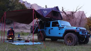
The “trailhead” for Poverty Wash Road is located roughly 2.8 miles east of the Zion National Park border (turnoff GPS 37.24233, 112.81344). Follow this road in a bit and you will find dispersed camping and areas to park a trailer. The trail is an old cattle trail that heads south from Route 9 into Utah State Trust and BLM land to reach the East Fork of the Virgin River.
Closer to Mt. Carmel Junction and further upriver on the EastFork Virgin River is the barracks Trail: https://utvguide.net/ridespotbarrac...
Route Closed?
BLM has released the Trail Canyon Travel Management Plan. In this plan, alternatives are listed that include closure of routes including the Poverty Wash Road, Barracks Trail, and Hell Dive Canyon to Lambs Point. Visit Utah Public Lands Alliance https://utahpla.com to help fight these closures!
Please be respectful of the land and others who will use it. Be sure to haul off your trash and stay on existing trails.