LULC Satellite Image Classification Using Machine Learning: How to Prepare Dataset Data Preparation

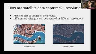
In this video, we will prepare our dataset for the land use land cover classification task using Sentinel2 satellite data and machine learning algorithms. This tutorial will help you understand how to prepare satellite data for an image classification task using machine learning algorithms.
The code examples are available on our GitHub page:
https://github.com/BEEILAB/LULCClass...
The dataset can be found in the following link:
https://github.com/iremozcann/LandCo...
Subscribe for more tutorials like this: / @beeilabtv
RELATED VIDEOS
Playlist with all our videos on land use and land cover classification using machine learning:
• LULC Satellite Image Classification U...
Other Social:
Instagram: / beeilab
Website: https://mahdianpari.ca/
Twitter: https://twitter.com/beeilab?lang=en
LinkedIn: / beeilab