Key Tips for Site Grading (BEGINNER)

Are you an aspiring civil engineer looking to master the fundamentals of grading? Join me as we walk through a beginnerfriendly grading exercise in a residential neighborhood. In this stepbystep tutorial, we'll cover the key elements every aspiring civil engineer should know when it comes to grading.
DISCLAIMER: THIS IS FOR BEGINNERLEVEL CIVIL ENGINEERS.
What is grading?
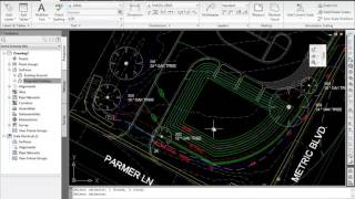
"Grading" refers to the process of altering or shaping the surface of the land to achieve a desired slope or elevation. Grading is typically performed to prepare a site for construction, improve drainage, create roads, or make the land more suitable for its intended use. Here are some key aspects of grading:
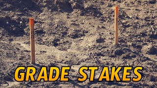
Leveling and Shaping: Grading involves the removal or addition of soil and earthmoving activities to create a smooth and even surface. This can include cutting into existing terrain (excavation) or filling in low areas (filling) to achieve the desired topography.
Slope and Drainage Control: Grading is used to establish specific slopes and gradients on the land, which are important for controlling water runoff and preventing erosion. Proper grading ensures that water flows away from structures and roads to prevent flooding.
Site Preparation: Grading is a crucial step in preparing a site for construction. It creates a stable and level surface on which buildings, roads, or other infrastructure can be built.
Road and Infrastructure Development: Grading is essential for the construction of roads, highways, parking lots, and other transportation infrastructure. It ensures that these surfaces are safe, properly sloped, and capable of supporting heavy loads.
Landscaping and Aesthetics: Grading is also used in landscaping to shape the land for aesthetic purposes, such as creating terraces, slopes, or contours in gardens and parks.
Key Moments:
#1 Observe the world around you
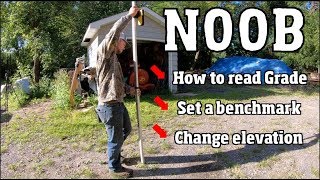
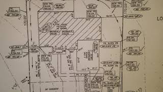
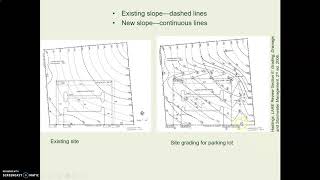
#2 Understand the existing grade of the site (what are the elevations?)
#3 Understand the typical slopes you will use (minimums, maximums, typicals)
Subscribe to learn more about the field of land development! My channel will expose you to technical programs like AutoCAD/WaterCAD/ICPR, engineering tips and tricks, and professional development.
Also, I'm a selfpublished author. I wrote my first book to inspire a generation of students. Feel free to check it out below!
https://www.amazon.com/BoundlessChoo...