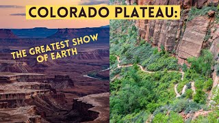
How the Colorado Plateau Formed u0026 Rose 8500 Feet

The Colorado Plateau covers vast stretches of Arizona, Colorado, Utah, and New Mexico, spanning 130,000 square miles. This large area has been uplifted by 8,500 feet during the last 100 million years which occurred in three distinct phases. So, how exactly was the Colorado Plateau uplifted, and what link does it share to modern volcanism in the area? This video will answer that question and discuss the formation of the Colorado Plateau.
Thumbnail Photo Credit: This work "Landslide9", is a derivative of a photo (resized, cropped, text overlay, GeologyHub made graphics overlay (the GeologyHub logo and the image border)) from "2015_02_10_laxewr_313", by: Doc Searls, docsearls, 2015, Posted on Flickr, Flickr account link: https://www.flickr.com/photos/docsearls/, Photo link: https://www.flickr.com/photos/docsear..., CC BY 2.0. "Landslide9" is used & licensed under CC BY 2.0 by / geologyhub .
If you would like to support this channel, consider using one of the following links:
(Patreon: / geologyhub )
(YouTube membership: / @geologyhub )
(Gemstone & Mineral Etsy store: http://prospectingarizona.etsy.com)
(GeologyHub Merch Etsy store: http://geologyhub.etsy.com)
Google Earth imagery used in this video: ©Google & Data Providers
This video is protected under "fair use". If you see an image and/or video which is your own in this video, and/or think my discussion of a scientific paper (and/or discussion/mentioning of the data/information within a scientific paper) does not fall under the fair use doctrine, and wish for it to be censored or removed, contact me by email at [email protected] and I will make the necessary changes.
Various licenses used in sections of this video (not the entire video, this video as a whole does not completely fall under one of these licenses) and/or in this video's thumbnail image (and this list does not include every license used in this video and/or thumbnail image):
Public Domain: https://creativecommons.org/publicdom...
CC BY 2.0: https://creativecommons.org/licenses/...
CC BY 4.0: https://creativecommons.org/licenses/...
Sources/Citations:
[1] Roberts, G. G., N. J. White, G. L. MartinBrandis, and A. G. Crosby (2012), An uplift history of the Colorado Plateau and its surroundings from inverse modeling of longitudinal river profiles, Tectonics, 31, TC4022, doi:10.1029/2012TC003107.
Note: This source was cited when showing the speed/rate, timing, and total uplift of the Colorado Plateau.
[2] U.S. Geological Survey
[3] Andersen, J., Göğüş, O.H., Pysklywec, R.N. et al. Symptomatic lithospheric drips triggering fast topographic rise and crustal deformation in the Central Andes. Commun Earth Environ 3, 150 (2022). https://doi.org/10.1038/s4324702200..., CC BY 4.0
[4] He, John & Kapp, Paul. (2023). Basin record of a Miocene lithosphere drip beneath the Colorado Plateau. Nature Communications. 14. 10.1038/s41467023401477. CC BY 4.0.
[5] Levander, A., Schmandt, B., Miller, M. et al. Continuing Colorado plateau uplift by delaminationstyle convective lithospheric downwelling. Nature 472, 461–465 (2011). https://doi.org/10.1038/nature10001
[6] The Google Earth KMZ file used in this video used to show the Geologic Map of Arizona was downloaded from: U.S. Geological Survey, Arizona geologic map data, at https://mrdata.usgs.gov/geology/state...
0:00 Colorado Plateau
1:24 Timing of Uplift
1:54 Plate Subduction
3:39 Ongoing Lithospheric Drip