Chicago-Honolulu flight leaves O'Hare snowplows for Hawaiian sprinkles 2011-12-09
Now fully annotated on screen: Passing 25,000 to 30,000 feet below are Mid West towns, the Mississippi, Wyoming plateaux, Rockies peaks, UtahNevada desert, California's Central Valley, Sacramento Delta, northern San Francisco Bay, Point Reyes, eastern north Pacific Ocean, Koko Head, downtown Honolulu, Barbers Point, and Ewa Beach on a ninehour flight condensed into 1/4 its length on a clear day along the complete flight path.
Specific passages:
Beginning of video: Boarding the flight at O'Hare
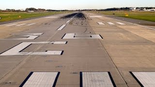
4:154:25 O'Hare snowplow completing a morning's runway clearance operation (seen while taxiing to runway)
5:50 Distant skyline of downtown Chicago (while awaiting takeoff clearance)
7:40 Takeoff on 32R (runway closed in 2015: Seehttp://www.dailyherald.com/article/20...)
8:40 Maine West High School, Des Plaines IL (Xshaped building)
9:10 Interstate90 at Elk Grove Village northwest of Chicago
9:4510:10 Ned Brown Preserve of Cook County IL
10:1010:20 Schaumburg IL
13:05 Interstate 90 crossing Fox River in north Elgin IL
17:30 Belvidere IL
18:30 Junction of Interstate 90 & Interstate 39 at Cherry Valley IL
19:15 Rock River through Rockford IL
21:40 Pecatonica IL (with ovalshaped Winnebago County Fairgrounds south of Pecatonica River)
23:10 Freeport IL
24:45 US 20 from the east curves into the town of Elizabeth located in the northwest corner of Illinois
25:20 Mississippi River (separating Illinois from Iowa) coming into view
26:0027:50 Dubuque, IA
28:10 Dubuque Regional Airport (DBQ)
29:0029:20 Dyersville IA
29:4530:40 Manchester IA
31:25 Independence IA
32:2034:25 Cockpit announcement on flight path
33:25 Jesup IA
34:1535:20 Waterloo IA
34:30 Waterloo Regional Airport (ALO)
35:2035:50 Cedar Falls IA
36:30 Dike IA
38:10 Dows IA west of Interstate 35
39:5040:00 Newell IA
40:4541:30 Storm Lake IA
42:20 Cherokee IA
42:45 Washta IA (coldest place in Iowa), next to Little Sioux River
https://en.wikipedia.org/wiki/Washta,...
43:30 Pierson IA
44:10 Kingsley IA
45:10 La Mars IA
46:30 Sioux City IA
46:5047:25 Big Sioux River separating Iowa from South Dakota
47:3548:10 Missouri River separating South Dakota (SD) from Nebraska (NE)
48:1048:25 Ponca NE
48:4048:50 Missouri River separating South Dakota (SD), above, from Nebraska (NE), below
49:20 Hartington NE
50:0551:10 Lewis & Clark Lake NE (near side) / SD (far side)
51:20 Bloomfield NE
52:0053:05 Beginning of Sandhills landscape of western Nebraska
53:0554:35 Missouri River continues west
55:45 Hyannis NE as Highway 2 / 61 winds west through the Sandhills
1:00:40 Bridgeport NE & North Platte River
1:03:001:03:50 Highway 71 south of Scottsbluff NE; leaving Nebraska & entering Wyoming (WY)
1:05:351:05:55 Exit 21 of Interstate 25 @ Ridley Road, 14 miles north of Cheyenne Wyoming; beginning of Rockies foothills
1:07:351:07:50 Interstate 80 winds west of Cheyenne towards Laramie WY
1:07:501:08:15 Laramie WY
1:10:25 Beginning of Snowy Range of Rockies; leaving Wyoming & entering Colorado (CO)
1:23:00 Dinosaur National Monument (CO); leaving Colorado & entering Utah (UT)
1:25:451:26:20 Vernal UT
1:28:001:28:30 Bottlehollow Reservoir, Fort Duchesne UT
1:28:401:29:15 Roosevelt UT
1:31:15 Duchesne UT
1:32:401:33:30 Strawberry Reservoir (larger of two lakes)
1:35:001:38:45 Wasatch Range
1:38:501:39:00 Nephi UT
1:39:301:40:05 western Utah ranges; leaving Utah & entering Nevada (NV)
1:42:001:43:05 Walker Lake NV; leaving Nevada & entering California (CA)
1:46:45 A flyalong
1:49:001:50:20 New Melones Lake CA
1:51:50 Central Valley foothills reservoirs: Camanche (L), Pardee (C), New Hogan (R) CA
1:53:501:55:10 Stockton CA
1:55:00 Interstate 5 through northwest Stockton CA
1:55:10 Sacramento River delta
1:57:001:58:20 Oakley / Antioch / Pittsburgh / Bay Point (of East San Francisco Bay Area) CA
1:59:00 Interstate 680 crossing the Sacramento River CA
1:59:25 Carquinez Bridge of Interstate 80 crossing Sacramento River
2:00:002:00:35 Tormey, Hercules, Pinole (of East San Francisco Bay Area) CA
2:00:40 Northern San Francisco Bay CA
2:01:352:02:35 San Rafael CA
2:02:50 Kent Lake CA
2:03:35 Drakes Bay CA
2:04:50 Point Reyes CA
2:05:00 Flight clears North American continent at Point Reyes CA
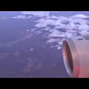
2:05:002:21:45 Crossing the northeastern Pacific to Hawaii
2:12:552:16:32 Announcement of Hawaiian agricultural declaration requirements
2;16:58 Arrival weather information from cockpit
2:21:55 Approaching Oahu's windward coast
2:21:552:22:50 Koko Head, Hanauma Bay & Hawaii Kai
2:24:15 Downtown Honolulu
2:24:50 Honolulu International Airport (HNL)
2:25:20 Barbers Point
2:29:00 Ewa Beach
2:30:40 Touchdown on runway 8L at HNL
2:34;35 Airside garden in airport terminal
2:35:05 The Bus bus stop in front of terminal
URL to this flight as tracked on Flightaware:
http://flightaware.com/live/flight/AA...


![B747 Pilot Got Promoted For This Emergency Landing [XP11]](https://i.ytimg.com/vi/cqQ0GvjZ-_g/mqdefault.jpg)


![*With ATC* UAL934 Los Angeles to Heathrow 777200ER [Full Flight]](https://i.ytimg.com/vi/8MtUrodROJk/mqdefault.jpg)


![Brand New! United A321NEO Roaring Takeoff from Chicago O'hare [HDR]](https://i.ytimg.com/vi/4DhOQuEjZME/mqdefault.jpg)