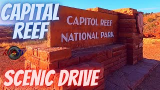
Capitol Reef National Park 4K - Scenic Drive - Utah USA
Thursday evening drive through Capitol Reef National Park in the western US State of Utah. A few more videos from this area then I may be in the middle east. TBD. I've figured out a few important things with filming lately. So the next videos should be better. Thanks everyone for your feedback and hope you are all doing well!
Starting Point: https://maps.app.goo.gl/9vj3EXqn4KXfC... .
Capitol Reef National Park is in Utah's southcentral desert. It surrounds a long wrinkle in the earth known as the Waterpocket Fold, with layers of golden sandstone, canyons and striking rock formations. Among the park's sights are the Chimney Rock pillar, the Hickman Bridge arch, and Capitol Reef, known for its white sandstone domes. In the north are the towering monoliths of Cathedral Valley. ― Google
Capitol Reef National Park is an American national park in southcentral Utah. The park is approximately 60 miles (100 km) long on its north–south axis and just 6 miles (10 km) wide on average. The park was established in 1971 to preserve 241,904 acres (377.98 sq mi; 97,895.08 ha; 978.95 km2) of desert landscape and is open all year, with May through September being the highest visitation months.
Partially in Wayne County, Utah, the area was originally named "Wayne Wonderland" in the 1920s by local boosters Ephraim P. Pectol and Joseph S. Hickman.[4] Capitol Reef National Park was designated a national monument on August 2, 1937, by President Franklin D. Roosevelt to protect the area's colorful canyons, ridges, buttes, and monoliths; however, it was not until 1950 that the area officially opened to the public.[4] Road access was improved in 1962 with the construction of State Route 24 through the Fremont River Canyon.
The majority of the nearly 100 mi (160 km) long upthrust formation called the Waterpocket Fold—a rocky spine extending from Thousand Lake Mountain to Lake Powell—is preserved within the park. Capitol Reef is an especially rugged and spectacular segment of the Waterpocket Fold by the Fremont River. The park was named for its whitish Navajo Sandstone cliffs with dome formations—similar to the white domes often placed on capitol buildings—that run from the Fremont River to Pleasant Creek on the Waterpocket Fold. Locally, reef refers to any rocky barrier to land travel, just as ocean reefs are barriers to sea travel.
https://en.wikipedia.org/wiki/Capitol...
https://home.nps.gov/care/index.htm


![★ 4K St. Moritz Chur Glacier express cab ride w/ heavy snowfall [02.2024] Führerstandsmitfahrt](https://i.ytimg.com/vi/rbW4-x6vJmk/mqdefault.jpg)


![Driving from Germany to France through the Northern Vosges [Driver's View]](https://i.ytimg.com/vi/IaaIpg1Vxlg/mqdefault.jpg)