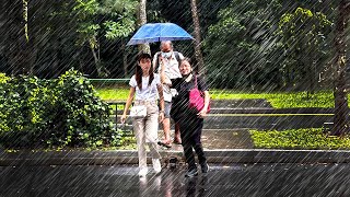
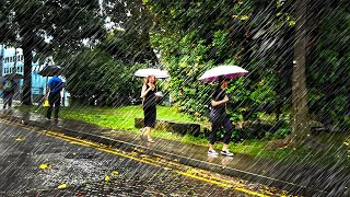
4K Walking In Heavy Rain Along The Rail Corridor at Kranji Singapore : Rain Drops on Umbrella ASMR

The Singapore Rail Corridor is a 26km long rightofway that used to route trains from the Malaysian Peninsula to Singapore for almost a century. A continuous and seamless corridor, it runs through the whole island of Singapore along the northsouth axis, from Woodlands in the north to Tanjong Pagar in the south. In 2011, the Keretapi Tanah Melayu(KTM) railway company, owned at the time by the Malaysian government, ceased operations and the railways lands reverted back to the Government of Singapore, which is now evaluating its conversion to a green space for recreation and nonvehicular commuting. The combined area of the rail corridor is approximately 173.7 hectares – three times the size of Botanical Gardens. But as a former foreignowned rail rightofway, the rail corridor has grown separate from the city, with very limited connectivity to the surrounding built environment and people.
Since the reopening of the corridor to the public in 2012, there has been intense interest over the future potential of the site (Peng and Hong 2011, Yong 2010). While no specific plans describing how the site is going to be developed have yet been released by Urban Redevelopment Authority (URA), the Government of Singapore has expressed intention to study the “possibility of maintaining a continuous green link along the Rail Corridor without affecting the development potential of the lands”.
Regardless of what the future holds for the corridor, one can hardly overstate the importance of the site for enhancing liveability in Singapore. The sites passed by the corridor contain numerous housing estates, businesses, MRT and bus stops and important cultural institutions in close distance. A great number of residents and employees could potentially benefit from the corridor being developed into a long and seamless park. Enhancing accessibility to the corridor from the surrounding areas will play a crucial role in developing the site. A betteraccessed and less restricted corridor would lead to a better integration with the surrounding built environment, maximizing opportunities for people to go to work by bicycle, on foot or even run.
https://cityform.mit.edu/projects/50
WATCH NEXT : Another thunderstorm rain walk in Geylang, Singapore :
• 4K GEYLANG RED LIGHT DISTRICT SUPER H...
Here is a list of my gear :
DJI Osmo Pocket 2 : https://amzn.to/3gjZRXc
Zoom H5 Sound Recorder : https://amzn.to/3x5jdoz
Sandisk 256GB Micro USB : https://amzn.to/3amcLjz
Boya MM1 Microphone : https://amzn.to/3gjLiCP
Sennheiser Ambeo Binaural Microphone : https://amzn.to/2QC8p0r
Wanderlust : A History of Walking : https://amzn.to/2OWArDw
The carbon footprint generated by this YouTube channel is offset through Ecologi, an organisation dedicated to planting 10 billion trees. Donate to Ecologi via my referral link : https://ecologi.com/ambientwalking?r=...
Support me on Kofi! : https://kofi.com/ambientwalking
Check out my merch : https://society6.com/ambientwalking


![[EXCLUSIVE] SMRT CCL TRAIN TO KIM CHUAN DEPOT](https://i.ytimg.com/vi/LvgeXzcCV-4/mqdefault.jpg)