2024 PORTAGE MICHIGAN TORNADO - Full Path 4k Drone Tracking Flight

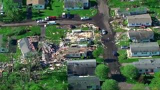
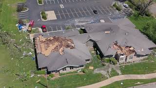
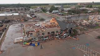
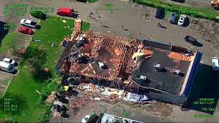
On May 7th, 2024, a high end rain shrouded EF2 ripped through the City of Portage and neighboring areas.
This video was filmed with a drone, from start to finish along the path of destruction from the tornado. Due to the fact that the tornado crossed over an active runway, it was not possible to follow the exact path of damage in that area.
Additionally, the Kalamazoo Airport operates under Class D airspace, the restrictions of which increase the closer one gets to the airport which is why the altitude of the drone incrementally decreases from 400 feet at the beginning of the video, down to 50 feet, and gradually back up to 400 feet towards the end of the video.
All of the footage along the path of the tornado was shot in small segments, in order to comply with FAA sUAS line of site operation regulations, as well as avoiding operations over human beings and operations over moving vehicles.
Injuries from the storm were minimal, and miraculously, no one was killed.
Several other tornadoes touched down in Michigan that evening.
The National Weather Service produced a damage survey with the following information about the tornado:
Rating: EF2
Max Winds: 135 MPH
Max Width: 300 Yards
Path Length: 11 Miles
Time on Ground: 22 Minutes (5:55PM 6:17PM)
Filmed on May 11th, 2024, with a DJI Mavic 3 Pro drone.
All federal, state, and local laws were followed in the production of this video.
For use or business inquiries, please contact:
Caleb Staufer
[email protected]